Import and export
Import and Export are in the list of projects and apply to the open project.
Exporting
Project → press and hold the project → Export offers six formats, seven with the Pro package. Under each one, geosit tells you what it will contain and with which elevations.
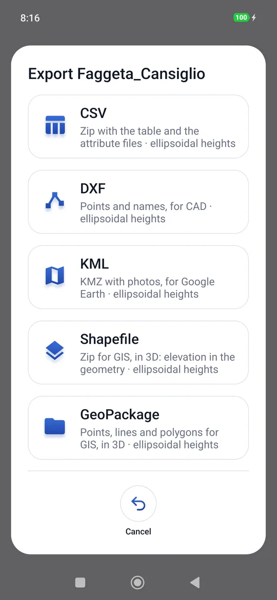
| Format | What comes out | For whom |
|---|---|---|
| CSV | The point table; with photos, audio or videos, a zip with the table and the allegati/ folder |
Excel, a GIS, the office |
| DXF | Points and names in grid coordinates | CAD |
| Site sketch PDF and Layered DXF | Only in scenes: the drawing for the report and the DXF with one layer per element | Report, expert, CAD |
| KML | The points with name, code and attributes; with photos, a KMZ that contains them | virtual globes, a GIS, anyone with a phone |
| Shapefile | A zip with one 3D Shapefile per layer (points, lines, polygons): elevation in the geometry, data in the table | A GIS |
| GeoPackage | A single .gpkg file with the same layers in 3D |
A GIS |
| Raw data files | The raw data files of static, kinematic and Stop & Go, with their .csv |
Post-processing |
Once the format is chosen, the Android share sheet opens: email, Drive, WhatsApp, Bluetooth, a folder on the phone… The person in the field chooses; geosit does not need to know where the file goes.
The file takes the name of the project (for example Faggeta_Cansiglio.csv). If the project
is empty, geosit says so: The project is empty.
CSV
One row per point, with the comma as separator and the point as decimal mark. The columns:
| Column | Content |
|---|---|
Nome |
Point name |
Codice |
Code |
Latitudine, Longitudine |
WGS84 decimal degrees, 9 decimals |
Quota ellissoidica or Quota slm ITG2009 |
The ground elevation, in meters. The column name says which elevation it is; outside the geoid grid the a.s.l. cell stays empty. |
Est, Nord, EPSG |
Grid coordinates in the project's reference system, to the millimeter, and its EPSG code. Older CSVs, with the Fuso column, are still read. |
PrecisioneH, PrecisioneV |
Accuracy estimated by the receiver, in meters (empty if not reported) |
Qualita |
The solution: FIX, FLOAT… |
Palina |
Pole height |
Data |
Date and time of the measurement |
| one column for each attribute | See Point attributes |
Opening the CSV with Excel
With Excel in Italian, opening the file with a double click may put everything in one column. Better Data → From Text/CSV, comma separator. The coordinates have the decimal point.
With attachments, the zip contains Faggeta_Cansiglio.csv and the allegati/ folder with
the files named in the cells (allegati/P6_Foto_20261026_090032.jpg).
DXF
A DXF R12 file, the most readable by any CAD: a point for every point (layer PUNTI) and
its name written next to it (layer NOMI), in grid coordinates of the project's system with
the elevation. A comment at the top of the file states the system (with the EPSG code) and the type of elevation.
The attributes are not in the DXF.
KML and KMZ
One placemark per point, with name, code and attributes (in the data table and in the balloon). The document description says which elevations they are. The points are clamped to the ground: the terrain model of virtual globes is off by a few meters, and with the true elevations the points would end up floating or buried; the elevation is still written in the coordinates.
If there are photos a KMZ comes out (doc.kml plus the photos), and the balloon of each
point shows its photo.
Shapefile and GeoPackage
For GIS, in 3D: the project's elevation (ellipsoidal or above sea level) is in the geometry
of every point and every vertex, as well as in the quota_ell or quota_slm column. Plane
coordinates in the project's reference system (the .prj and the GeoPackage carry its EPSG code), with the CSV columns (nome, codice,
latitudine, longitudine, the elevation, est, nord, prec_h, prec_v, qualita, palina,
data) and one column per attribute.
| Layer | Geometry | Columns |
|---|---|---|
punti |
3D point | those of the CSV and the attributes |
linee |
3D line | numero, codice, vertici, lunghezza (horizontal, m) |
poligoni |
3D polygon | numero, codice, vertici, perimetro (m) |
Lines and polygons are there only if the project has them. The Shapefile is a zip
(Faggeta_Cansiglio-shp.zip) with .shp, .shx, .dbf, .prj and .cpg for each layer: column
names are shortened to ten letters (an attribute with a non-Latin name becomes ATTR13) and texts
are in UTF-8. The GeoPackage (Faggeta_Cansiglio.gpkg) is a single file, with full column
names. A point without elevation (an imported target) has an empty elevation column and Z 0 in the
geometry.
Raw data files
Sends all the raw data files of the project (static, kinematic and Stop & Go):
each .ubx raw data file with its .csv, and the kinematic _segni.csv files. If the
project has none: No raw data files.
Importing points from a CSV
To stake out points prepared in the office: Project → press and hold the project → Import and choose the CSV file.
geosit understands the CSV files that really come from offices:
- separator comma, semicolon or tab (with semicolon or tab the decimal comma is fine: it is the CSV of Excel in Italian);
- with or without a header row;
- grid coordinates (name, easting, northing, elevation) in the project's reference system, or geographic ones (name, latitude, longitude, elevation) in decimal degrees;
- the elevation is optional.
With the header, the columns are recognized by their name:
| What | Recognized names |
|---|---|
| Name | nome, name, punto, point, id |
| Latitude / Longitude | lat, latitudine, latitude / lon, lng, longitudine, longitude |
| Easting / Northing | est, east, e, x / nord, north, n, y |
| Elevation | quota…, h, z, alt, altezza, height, elevation, q |
| Code | codice, code, descrizione |
| Attributes | The exact name of an attribute of the project (case aside) |
For each item the first column with its name counts: a later column with the same name (for example an «Altezza» attribute after the elevation) stays an attribute. If there is no name column, the points are numbered in file order. Files saved by Excel with accented letters (Windows encoding) are read as they are.
Without a header the order is: name, easting (or latitude), northing (or longitude), elevation.
Example:
Nome;Est;Nord;Quota slm ITG2009;Codice
F1;300850,123;5105050,456;1012,35;Faggio
F2;300870,500;5105071,900;1013,10;Abete rosso
The imported points appear in orange on the map and come first in the stakeout list. At the end geosit says what it has done: 12 points imported into Faggeta_Cansiglio · 2 already present, skipped · 1 row skipped.
The elevations in the file
If the elevation column says which elevation it is (Quota slm…, s.l.m., ortometrica,
ITG for sea level; ellissoidica for the ellipsoid), that one applies. If it does not
say, geosit reads it as the elevations of the project it is imported into.
Duplicates
A point with the same name and the same coordinates (within a millimeter) as one that is already there is not imported twice: importing the same file again does not create duplicates.
The CSV exported by geosit
A CSV exported by geosit and imported again comes back as it was: measured points stay measured, with solution, precisions, pole height and measurement date; points added by hand stay added by hand. Only points without a solution become points to stake out. This applies when the header row is geosit's own.
The zip exported by geosit
The zip that geosit exports (CSV with photos, audio or video) can be imported too: the
points come in as from a CSV, and the files in allegati/ go back into the photo, audio and
video attributes with the same name, if the project has those attributes. Importing it again
creates no duplicates, neither of points nor of files. The attachments have a limit:
200 MB per file and 1 GB in total; beyond that, geosit does not import the zip and says so.
If the file has no readable point geosit says so (No points found) and nothing changes in the project.
If the project is in UTM and some points fall outside the zone (more than one degree past its edge), geosit warns you after the import: it usually means east and north swapped, or latitude and longitude in place of plane coordinates. The points stay imported, so you can check them and delete them from the list of points.
Importing a DXF drawing
With the Pro package, Import also accepts a DXF drawing: geosit recognizes which coordinates it is in (and asks for the zone or to download the reference systems if needed), brings it into the project's system, puts it on the map and lets you snap to its points to create them and stake them out. All of it in CAD drawings and snap.
Importing an offline map
An .mbtiles file chosen from Import is not a list of points: geosit recognizes it and
installs it as an offline map.